Current filter:
Special meetings of both the Regional Planning Committee and Regional Council on Wednesday 18 March 2020 resulted in the decision to publicly notify the proposed TANK Plan Change, which contains new rules and limits to protect and improve the Heretaunga Plains waterways.
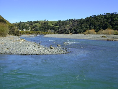
Hawke’s Bay Regional Council proposes to add new rules to the Regional Resource Management Plan to manage water quality and quantity for the Tūtaekurī, Ahuriri, Ngaruroro and Karamū catchments, known as TANK.
According to Regional Council Chair Rex Graham this is a momentous decision, bearing testament to the collaborative efforts of the 30-plus member TANK Group, the Regional Planning Committee and staff who have been developing the TANK Plan since 2012.
“This complex catchment plan change for the Heretaunga Plains waterways follows extensive scientific investigation and cross-table stakeholder debate. This plan will help us to manage the long-term health of the rivers and land around Napier and Hastings and the aquifer below,” says Mr Graham.
Regional Planning Committee Co-Chair Joinella Maihi-Carroll supports notifying the proposed TANK Plan Change.
“Tāngata Whenua are very keen to have a plan to move forward with, and the means to better protect these waterways”, says Ms Maihi-Carroll.
“We welcome all submissions to the TANK Plan so that we can get these important rules in place,” adds Ms Maihi-Carroll.
The TANK Plan approach began with a broad stakeholder group including tāngata whenua, businesses, industry, sector, councils and environmental interests. The plan’s development gives effect to previous government direction on freshwater and will in time be reviewed against future government proposals.
The proposed TANK Plan Change will be publicly notified and open for public submissions from 28 March until Friday 29 May 2020.
The TANK Plan deals with land and water use, and water quality and quantity of these major waterways and their tributaries and the interconnected Heretaunga Plains aquifer beneath. More information can be found at hbrc.govt.nz, search: #TANK.
18 March 2020
+64 6 835 9200
159 Dalton Street. Napier 4110
Private Bag 6006, Napier 4142
Disclaimers, Copyright & Privacy
![]()
Disclaimers and Copyright
While every endeavour has been taken by the Hawke's Bay Regional Council to ensure that the information on this website is
accurate and up to date, Hawke's Bay Regional Council shall not be liable for any loss suffered through the use, directly or indirectly, of information on this website. Information contained has been assembled in good faith.
Some of the information available in this site is from the New Zealand Public domain and supplied by relevant
government agencies. Hawke's Bay Regional Council cannot accept any liability for its accuracy or content.
Portions of the information and material on this site, including data, pages, documents, online
graphics and images are protected by copyright, unless specifically notified to the contrary. Externally sourced
information or material is copyright to the respective provider.
© Hawke's Bay Regional Council - www.hbrc.govt.nz / +64 6 835 9200 / info@hbrc.govt.nz