Current filter:
Hawke’s Bay Regional Council is about to begin a region-wide monitoring programme of riparian zones.
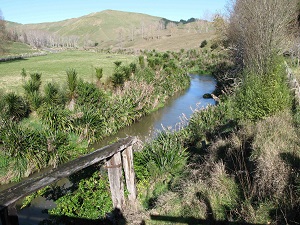
Riparian zones are the area between the land and the waterways. When well-maintained they can act as a crucial buffer trapping nutrients, sediments and bacteria before they enter the water. They also provide an important habitat for aquatic and terrestrial plants and animals and can also provide safe ‘corridors’ allowing movement of species across the landscape.
In the past, the Council has conducted desktop analysis of riparian conditions in the region, using aerial imagery to examine the level of stock access to waterways and the extent and condition of riparian vegetation. However, this method only provides a snapshot in time and interpretation of imagery can be subjective depending on the viewer.
The new monitoring method will involve on the ground investigation of several hundred riparian sites. The number and location of these sites have been specifically chosen to enable the statistical representation of the entire region.
Hawke’s Bay Regional Council Resource Analyst – Land Science, Jamie Wu says “this new approach will provide details on the amount of fencing, vegetation, erosion etc. and will provide a picture of the region’s riparian condition and allow changes to be monitored in the future”.
“We will begin monitoring in the Tukituki Catchment, before expanding the monitoring across the whole region catchment by catchment. We will return to individual sites on a five yearly basis,” says Jamie Wu.
The data from the first round of the survey will be used to benchmark the current state of riparian conditions and to highlight any future improvement or deterioration in these areas.
3 May 2018
+64 6 835 9200
159 Dalton Street. Napier 4110
Private Bag 6006, Napier 4142
Disclaimers, Copyright & Privacy
![]()
Disclaimers and Copyright
While every endeavour has been taken by the Hawke's Bay Regional Council to ensure that the information on this website is
accurate and up to date, Hawke's Bay Regional Council shall not be liable for any loss suffered through the use, directly or indirectly, of information on this website. Information contained has been assembled in good faith.
Some of the information available in this site is from the New Zealand Public domain and supplied by relevant
government agencies. Hawke's Bay Regional Council cannot accept any liability for its accuracy or content.
Portions of the information and material on this site, including data, pages, documents, online
graphics and images are protected by copyright, unless specifically notified to the contrary. Externally sourced
information or material is copyright to the respective provider.
© Hawke's Bay Regional Council - www.hbrc.govt.nz / +64 6 835 9200 / info@hbrc.govt.nz