Current filter:
Published: 3 June 2026
Hawke’s Bay Regional Council has completed updated flood hazard modelling for the Esk River, providing a more detailed and up-to-date picture of flood risk for communities in the Esk Valley.
The new flood hazard information uses the latest ground survey data, advanced computer modelling, and future climate change projections to better understand the likelihood and extent of flooding from the Esk River.
Regional Council Chair Sophie Siers says the updated modelling is an important tool for helping the Esk Valley community and councils plan more safely for the future.
“Having the best available information is critical. These updated flood hazard maps give us a clearer understanding of where flooding is likely to occur in the valley and how climate change could impact flooding in the future,” she says.
“This information supports better decision-making to reduce risk to people, homes and infrastructure over time, and has informed designs for the Whirinaki stopbank mitigation under construction.”
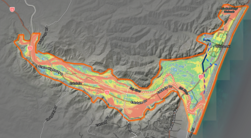
What the maps show
The Esk Valley has experienced large flood events over several decades, so it’s no surprise that the modelling identifies that significant parts of Esk Valley are at risk of flooding during a major event such as a 1-in-100-year flood (a flood with a one per cent chance of occurring in any given year), especially when climate change is considered.
Several different sized flood events have been modelled, as well as scenarios that factor in future climate change impacts.
How the information will be used
The flood hazard information will be used by Napier City Council and Hastings District Council for land-use planning purposes, including in the processing of building and resource consents and updating of District Plans.
The new modelling information has been provided to both councils so it can be included in Land Information Memorandums (LIMs) where they consider it relevant.
To support public access, the flood hazard mapping is now available online through a new interactive map viewer, allowing users to explore the different flood scenarios modelled across the Esk.
Whirinaki stopbank
“Stopbanks significantly reduce flood risk, but can never completely prevent it,” Chair Siers says.
“In very large events, particularly when climate change is taken into account, floodwaters can still go over the top of stopbanks. It’s important our communities understand both the benefits and the limits of flood mitigation.”
The Whirinaki stopbank, under construction – to be built to standards common across Hawke’s Bay and New Zealand – is expected to be completed by January 2027, is designed to reduce flood risk for parts of Whirinaki. The residential part of the project and the raising of the road is expected to be completed by late August. However, the modelling confirms that no flood mitigation structure can eliminate risk entirely.
Looking ahead
The Regional Council has an extensive programme of flood hazard modelling underway across other areas in the region, and these will be made public over the next year.
“Understanding flood risk is a key priority for the Regional Council and up-to-date and comprehensive flood hazard modelling is critical to improving resilience to flooding,” Chair Siers says.
“By investing in updated science now, we’re helping ensure our communities are better prepared for the future.”
View the Esk flood hazard modelling, FAQs and technical report here.
Photo: One of the hazard layers demonstrating modelled potential flood depths.
+64 6 835 9200
159 Dalton Street. Napier 4110
Private Bag 6006, Napier 4142
Disclaimers, Copyright & Privacy
![]()
Disclaimers and Copyright
While every endeavour has been taken by the Hawke's Bay Regional Council to ensure that the information on this website is
accurate and up to date, Hawke's Bay Regional Council shall not be liable for any loss suffered through the use, directly or indirectly, of information on this website. Information contained has been assembled in good faith.
Some of the information available in this site is from the New Zealand Public domain and supplied by relevant
government agencies. Hawke's Bay Regional Council cannot accept any liability for its accuracy or content.
Portions of the information and material on this site, including data, pages, documents, online
graphics and images are protected by copyright, unless specifically notified to the contrary. Externally sourced
information or material is copyright to the respective provider.
© Hawke's Bay Regional Council - www.hbrc.govt.nz / +64 6 835 9200 / info@hbrc.govt.nz