Current filter:
Published: 2 July 2026
Hawke’s Bay Regional Council (HBRC) has confirmed the properties, all on the northern side of the Pōrangahau River, have been removed from the Government’s Future of Severely Affected Land (FOSAL) risk categorisation framework.
Each had been classed as Category 2C after Cyclone Gabrielle – a designation used where flood risk was deemed unacceptably high, but where a workable, community-scale infrastructure fix could be found.
That solution is now taking shape in steel, soil and precise engineering along the riverbank.
With the first phase of the Pōrangahau Flood Resilience Project now well into construction, the 75 properties have met the test for the Category 2C label to come off. They have been removed from FOSAL altogether and no longer have a post-Gabrielle flood risk category attached.
Regional Council staff hand-delivered letters advising property owners of the change on Thursday.
HBRC Chair Sophie Siers says the decision gives the Pōrangahau community something it has waited three years for: a clearer path forward.
“This is so much more than just a technical change,” Chair Siers says. “For the people who have been living with Category 2C beside their address, it is a letter that says: the ground is firmer now, and you can plan for a future here in Pōrangahau.
“Cyclone Gabrielle took many things from Hawke’s Bay – lives, homes, land, infrastructure, livelihoods. But it also took something less visible: people’s sense of safety. That unconscious trust in the world around you. The ability to fall asleep when it rains without wondering what the river is doing.
“This decision helps give some of that back.”
Chair Siers stresses the decision should not be mistaken for a promise that the river will never flood again.
“No flood scheme can remove every risk,” she says. “But for these properties, the risk has been reduced to a level where the Category 2C label is no longer needed – and stronger protection is now being put in place.”
“For property owners, the letter brings immediate relief. The longer-term reassurance is coming from what they can now see on the riverbank: steel, soil and the first engineered flood protection for a town that has flooded many times.”
For HBRC councillor Thompson Hokianga, the decision lands close to home. He grew up in Pōrangahau and has enduring whakapapa ties to the whenua and to Rongomaraeroa Marae.
“Pōrangahau is a place that raised me, a landscape I know intimately, and a community I am accountable to, not only as an elected councillor but through whakapapa,” Cr Hokianga says.
“After Gabrielle, there was the damage you could see – the silt, the water marks, the ruined fences, the mess. But beneath that was the worry about what it would mean for homes, for whenua, and for the future of the town.
“So to have that category lifted for these homes is huge. It helps put that future back on solid ground – recorded in writing and made visible on the whenua through the stopbanks and flood walls.
“No one who lived through Gabrielle will forget it. But people need to feel there is a future to plan for – and this decision helps make that future feel possible again.”
The $14.6 million Pōrangahau Flood Resilience Project is part of Hawke’s Bay’s $256.5 million North Island Weather Events (NIWE) resilience programme – a regionwide investment in stronger flood protection after Cyclone Gabrielle. The project is funded 72 per cent by Central Government, with that contribution managed by National Infrastructure Funding and Financing (NIFF) through the Government’s Cyclone Recovery Fund. The remaining 28 per cent is funded by HBRC.
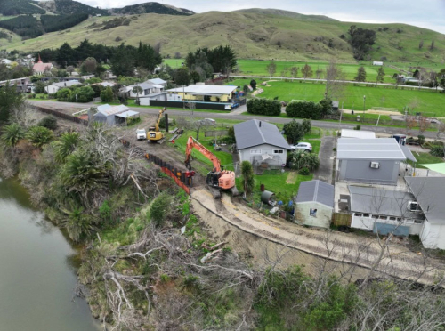
Its first phase is giving the northern side of Pōrangahau a stronger edge against future floods: a 1.7-kilometre network of stopbanks and sheet pile flood walls along the township side of the river.
Along that stretch, the project shifts between stopbanks and sheet pile flood walls, depending on what the land, river and nearby properties allow. It is practical, place-specific work: soil where there is room, steel where space is tight.
Construction is being carried out in five sections, with Galbraith Earthmovers leading the main build and Lattey Group installing the sheet pile walls.
The northern-side milestone is significant, but the Pōrangahau work is not finished.
Properties south of the river remain in Category 2C while the second phase moves through options analysis and design (which includes flood resilience options for Rongomaraeroa Marae, Kaumātua Flats, Kaiwhitikitiki Urupā and two private dwellings).
Chair Siers says this next phase needs time, care and partnership.
“The south side mahi involves places that matter deeply,” she says. “We are working carefully with mana whenua, landowners and the community so the options reflect the land, the people and the cultural importance of each site.
“The funding for phase two is in place within the approved project budget. Once the required criteria are met, we will move through the same category-change process for the south side.”
Chair Siers says this week’s news is a tribute to the people of Pōrangahau, who have stayed with the process through a long and difficult recovery.
“This progress has taken patience, persistence and local knowledge,” she says.
“It has only been possible because central government, regional government, mana whenua, contractors, landowners and the community have kept working together.
“For Pōrangahau, this is a hard-won step forward – and a clear sign the work is making a real difference.”
No one who lived through Gabrielle will forget it. But people need to feel there is a future to plan for – and this decision helps make that future feel possible again.”
- HBRC Councillor Thompson Hokianga

Funding: The Pōrangahau project is funded 72 per cent by Central Government and 28 per cent by HBRC.
Project status: Construction is being carried out in five sections, with Galbraith Earthmovers leading the main build and Lattey Group installing the sheet pile flood walls.
+64 6 835 9200
159 Dalton Street. Napier 4110
Private Bag 6006, Napier 4142
Disclaimers, Copyright & Privacy
![]()
Disclaimers and Copyright
While every endeavour has been taken by the Hawke's Bay Regional Council to ensure that the information on this website is
accurate and up to date, Hawke's Bay Regional Council shall not be liable for any loss suffered through the use, directly or indirectly, of information on this website. Information contained has been assembled in good faith.
Some of the information available in this site is from the New Zealand Public domain and supplied by relevant
government agencies. Hawke's Bay Regional Council cannot accept any liability for its accuracy or content.
Portions of the information and material on this site, including data, pages, documents, online
graphics and images are protected by copyright, unless specifically notified to the contrary. Externally sourced
information or material is copyright to the respective provider.
© Hawke's Bay Regional Council - www.hbrc.govt.nz / +64 6 835 9200 / info@hbrc.govt.nz