Current filter:
Published: 16 December 2021
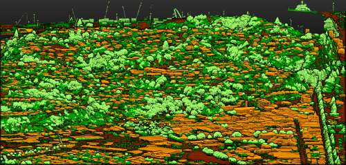
High-resolution 3D mapping of Hawke’s Bay using light detection and ranging (LiDAR) technology is now available for use by the community.
The Hawke’s Bay Regional Council has run the project on behalf of Central Hawke’s Bay District Council, Hastings District Council, Napier City Council and Wairoa District Council. The Provincial Growth Fund and all five councils have funded the project.
The project uses LiDAR to create high-resolution 3D models of the land surface and surface features of the entire Hawke’s Bay region.
This initial data release covers 1,250 square kilometres, including most towns and settlements in the region. The data includes the ground surface and features including buildings, structures, and forests.
The community can access the data at the LINZ Data Service, Open Topography and the Regional Council’s Open Data Portal.
Regional Council chair Rick Barker says the highly detailed 3D maps will be used by all the councils and contribute to economic development in the region.
“This is good news, these up to date maps will be of great value to the region in the long term, and give us a good insight of the geography of the region.
“We can better understand our waterways and river flows, what flood protection is required and the areas at greatest risk of flooding. We’ll also use the mapping for geohazard mapping including ground surface change, faults, liquefaction and slips,” he says.
The survey data will inform planning of facilities and infrastructure, roading design, land management decisions through erosion modelling, tracking the impact of rising sea levels, and stormwater design.
“The data will ultimately inform better planning and management of our environment, to create a more climate resilient future in Hawke’s Bay,” he says.
The Regional Council commissioned Australian company iXBlue to undertake the LIDAR survey in 2019. iXBlue partnered with Aerologistics, BECA, Mainland Air and Woolpert to deliver the LIDAR service.
The equipment was mounted in a specially adapted aircraft which was flown at high altitude shooting out pulses of light which bounced back from the ground to give a measurement of land elevation. This technique is used to create 3D elevation maps for large areas of land.
The data is complementary to the Regional Council’s recent 3D aquifer mapping survey which looked 300 metres underground.
Hawke’s Bay is one of ten regions partnering with Toitū Te Whenua Land Information New Zealand to obtain a baseline national data set. The aim is for LiDAR coverage of 80 per cent of New Zealand by the end of 2024. All data collected will be made available as government open data from Land Information New Zealand.
Co-funding from the Provincial Growth Fund is supporting the regional expansion of Toitū Te Whenua’s 3D mapping programme to provide a significant increase in national coverage.
Further data for Hawke’s Bay will be shared as it becomes available.
+64 6 835 9200
159 Dalton Street. Napier 4110
Private Bag 6006, Napier 4142
Disclaimers, Copyright & Privacy
![]()
Disclaimers and Copyright
While every endeavour has been taken by the Hawke's Bay Regional Council to ensure that the information on this website is
accurate and up to date, Hawke's Bay Regional Council shall not be liable for any loss suffered through the use, directly or indirectly, of information on this website. Information contained has been assembled in good faith.
Some of the information available in this site is from the New Zealand Public domain and supplied by relevant
government agencies. Hawke's Bay Regional Council cannot accept any liability for its accuracy or content.
Portions of the information and material on this site, including data, pages, documents, online
graphics and images are protected by copyright, unless specifically notified to the contrary. Externally sourced
information or material is copyright to the respective provider.
© Hawke's Bay Regional Council - www.hbrc.govt.nz / +64 6 835 9200 / info@hbrc.govt.nz