Current filter:
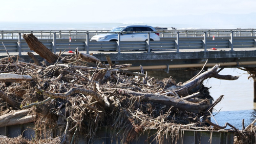
Hawke’s Bay Regional Council today released its report on the make-up of the woody debris that washed up against bridges, on beaches and ended up on flooded areas.
The Regional Council’s survey of deposited woody debris in the wake of Cyclone Gabrielle was undertaken at 17 sites where damage occurred to bridges or had accumulated on land or on beaches. These detailed assessments followed guidelines created and used in the Gisborne / Tairawhiti region.
The aim of the report was to understand the likely origins of large woody debris that washed down the waterways during Cyclone Gabrielle to help inform future land use planning.
Regional Council’s Group Manager – Asset Management Chris Dolley, says “the woody debris assessed in Hawke’s Bay consisted of a mixture pine, willow, poplar and ‘other’ - native timber and debris that could not be identified.”
“The woody debris composition differed from catchment to catchment and largely was the result of whatever tree species was predominant in the catchment upstream," says Mr Dolley.
The Regional Council were particularly interested to see whether the pine debris included harvested logs, “slash”, or were whole or parts of trees sourced from erosion of hillsides and streambanks.
“At all but one of the surveyed sites, there was little evidence of slash, indicating that the majority of pine came from erosion of hillsides and streambanks. The site with the most cut pine was Mangaone at Rissington, where 9 percent of the timber had cut marks,” says Mr Dolley.
The results are summarised below:
| Catchment / Area | Mix of debris |
| CHB* | Willow |
| Ngaruroro | Largely clear of debris |
| Upper Tutaekuri and Mangaone– Dartmoor and Rissington | Predominately pine with the remaining being willow |
| Lower Tutaekuri – Puketapu – Awatoto | Predominately willow / poplar with the remaining being pine |
| Esk River and Beach | Predominantly pine |
| Te Ngarue | Mix of pine and willow |
| Aropaonui (beach) | Predominantly pine |
| Waikare (beach)** | Predominantly pine |
| Mohaka (beach) | Predominantly pine with some ‘other’ |
| Wairoa (rivermouth)** | Predominantly pine |
| Mahia (beach) | Predominantly pine with some ‘other’ |
*Sites in CHB weren’t formally surveyed as it was evident from preliminary assessments that willow / poplar was the dominant timber source
** Waikare beach and Wairoa River mouth sites were assessed by air as access to a suitable site was not found
Pine plantations and wilding pine are found extensively across Hawke’s Bay. Much of the pine that was found at the sites tested constituted windthrown or previously dislodged pine, pine remaining from community operations or clearance, or general pine pieces that lacked evidential origins but were in the vicinity of flood waters and our river systems.
Willow is one of the most effective and commonly used species for both erosion and riparian margin control due to the strength of their rooting systems. Riverbank plantings are essential for edge protection from river flows, and they protect from slips, as well as providing stock shelter and supplementary feed on farms.
Willow proximity to rivers combined with the volume and strength of the flood waters from Cyclone Gabrielle have contributed to the willow found within the sites tested. Areas of riverbank willow plantings have remained in place despite the flood event, proving they remain one of the best options for erosion control.
The Hawke’s Bay Regional Council is working with the other councils in the region, and Waka Kotahi to ensure that flood control and bridges are considered together so the right decisions can be made around bridge deck heights and spans as we rebuild for the future.
The full post-cyclone large woody debris assessment can be found here: https://hbrc.info/woodydebris2023, and on our cyclone hub at hbrc.govt.nz, search #cyclone
ENDS
Note to editor
12 April 2023
+64 6 835 9200
159 Dalton Street. Napier 4110
Private Bag 6006, Napier 4142
Disclaimers, Copyright & Privacy
![]()
Disclaimers and Copyright
While every endeavour has been taken by the Hawke's Bay Regional Council to ensure that the information on this website is
accurate and up to date, Hawke's Bay Regional Council shall not be liable for any loss suffered through the use, directly or indirectly, of information on this website. Information contained has been assembled in good faith.
Some of the information available in this site is from the New Zealand Public domain and supplied by relevant
government agencies. Hawke's Bay Regional Council cannot accept any liability for its accuracy or content.
Portions of the information and material on this site, including data, pages, documents, online
graphics and images are protected by copyright, unless specifically notified to the contrary. Externally sourced
information or material is copyright to the respective provider.
© Hawke's Bay Regional Council - www.hbrc.govt.nz / +64 6 835 9200 / info@hbrc.govt.nz