Current filter:
Published: 22 February 2023
MetService has issued two weather watches for Hawke’s Bay through Saturday and the Regional Council is monitoring the situation. They are for possible severe weather Friday and Saturday.
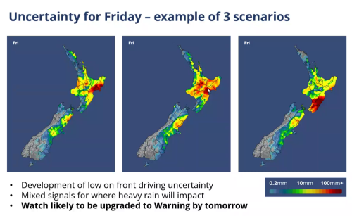
The possible Friday afternoon rain locations are still quite variable. The three scenarios show heavy rain in Wairoa, or Hawke’s Bay around Napier, or Central Hawke’s Bay and the southern coast.
The best option is to plan for any of these scenarios.
What MetService issued:
Severe Weather Watch
Issued by MetService at 8:41 am Wednesday 22-Feb-2023
Heavy Rain Watch
The charts show about 100 mm over 3 hours in CHB and southern HB on Friday around 7 p.m.
Most other time periods show scattered showers.
River level summaries
These are based on several scenarios – impacts from the Friday rain are still quite variable. A more accurate river forecast will take place on late on Wednesday or early Thursday.
Wairoa – Forecast rain is not significant for this large catchment, however, showers may cause smaller rivers to rise. Very unlikely to be significant rise in major rivers. Levels expected to stay below alert levels.
Esk – forecast up to 80 mm rain over 24 hours in upper catchment. Will cause small rise in river, very unlikely to be at berm level. Caution for areas where river has cut new channel. Minor surface flooding possible from rainfall. Caution needed around silt deposits becoming saturated.
Mangaone – Rissington to Dartmoor Road – up to 70 mm rain over 24 hours. Likely to see Mangaone rise about 0.5 m by 12 noon Thursday. If rain is persistent, may rise another 0.5m by early hours Friday Feb. 24. Caution needed around bridge rebuilds. If additional rain occurs all day Friday, expect river rises of an additional 1m in the afternoon to evening on Friday.
Tutaekuri – Dartmoor, Moteo, Puketapu – up to 70 mm rain over 24 hours. Likely to see Tutaekuri rise about 0.5m to 1m by early hours Friday Feb. 24. This is still within the berm levels, i.e. water is expected to stay in main channel, however, caution is needed if there has been a new channel formed between the main channel, through the berm and to any location of stop bank breach. Mapping of these locations is continuing. This water level rise is unlikely to cause any significant depth of water over any floodplain area if it were to escape the main river channel. If additional rain occurs all day Friday, expect river rises of an additional 0.5 m to 1m in the afternoon to evening on Friday.
Ngaruroro - up to 70 mm rain over 24 hours – Likely to see Ngaruroro at Fernhill rise about 1m by around 7am Friday Feb. 24. Present estimate is for water to remain in main channel, with a small chance to rise to berm level. Water is unlikely to cause any significant depth of water over any floodplain area if it were to escape the main river channel.
At the Ngaruroro River mouth, including Awatoto, the rise in water level is likely to be less than 1m. If additional rain occurs all day Friday, expect river rises of an additional 1m in the afternoon to evening on Friday. High tide at Napier is around 10am, low at 4pm.
Upper Tukituki – Scattered showers on Wed. to Thursday, with additional rainfall of up to 100 mm over 3 hours on Friday at 19:00. The Thursday rain will cause minor river level rises, unlikely to be significant, likely to remain below alert level. Friday rain is likely to cause short term spikes in minor rivers, and then a minor rise in the major rivers. Caution needed around stop bank breach areas if the river has carved a new channel to the breach location.
+64 6 835 9200
159 Dalton Street. Napier 4110
Private Bag 6006, Napier 4142
Disclaimers, Copyright & Privacy
![]()
Disclaimers and Copyright
While every endeavour has been taken by the Hawke's Bay Regional Council to ensure that the information on this website is
accurate and up to date, Hawke's Bay Regional Council shall not be liable for any loss suffered through the use, directly or indirectly, of information on this website. Information contained has been assembled in good faith.
Some of the information available in this site is from the New Zealand Public domain and supplied by relevant
government agencies. Hawke's Bay Regional Council cannot accept any liability for its accuracy or content.
Portions of the information and material on this site, including data, pages, documents, online
graphics and images are protected by copyright, unless specifically notified to the contrary. Externally sourced
information or material is copyright to the respective provider.
© Hawke's Bay Regional Council - www.hbrc.govt.nz / +64 6 835 9200 / info@hbrc.govt.nz