Current filter:
Published: 13 April 2018
A joint project between Hawke’s Bay Regional Council and NIWA with MPI co-funding aims to map a part of the Hawke Bay seabed known as the Wairoa Hard.
The Wairoa Hard covers just over 300 square kilometres of northern Hawke Bay between Moeangiangi and Wairoa Rivers and extending out 18 kilometres to where the ocean floor is 50 metres deep.
It is named for its coarse cobble substrate and is an area of national importance as it provides a nursery for juvenile fish, snapper, sharks, John Dory and trevally.
“This is an area that has been identified as significant in the coastal marine area for a number of services and functions, but we don’t know how it is doing health wise and we need a much better understanding of that,” says Anna Madarasz-Smith, HBRC senior coastal scientist.
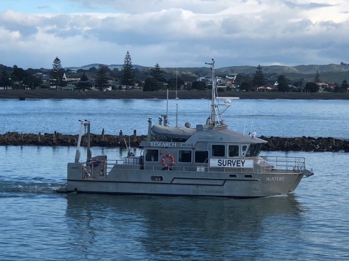
NIWA’s multipurpose coastal research vessel the ‘Ikatere’ arrived in Hawke’s Bay on Thursday 12 April. It is a 13.9m custom-designed catamaran which collects high-quality hydrographic data and has been involved in the mapping of more than 1,500,000km² of New Zealand’s seafloor using multibeam echosounder equipment.
NIWA staff will use multibeam mapping technology to map the shape and contours of the seafloor and identify different seafloor physical characteristics.
“These include the type of substrate or sediment (eg, hard gravel or soft mud) and what else is on and above the seafloor such as cables, kelp beds and biological aggregations (schooling fish),” says NIWA marine geology principal technician Steve Wilcox.
The mapping will take 10 days. This will be the first part in a programme to assess the current state of the Wairoa Hard.
The Wairoa Hard was closed to net fishing in 1981 and since then no assessment of its state has been made.
Photo: Ikatere heading for the Wairoa Hard
+64 6 835 9200
159 Dalton Street. Napier 4110
Private Bag 6006, Napier 4142
Disclaimers, Copyright & Privacy
![]()
Disclaimers and Copyright
While every endeavour has been taken by the Hawke's Bay Regional Council to ensure that the information on this website is
accurate and up to date, Hawke's Bay Regional Council shall not be liable for any loss suffered through the use, directly or indirectly, of information on this website. Information contained has been assembled in good faith.
Some of the information available in this site is from the New Zealand Public domain and supplied by relevant
government agencies. Hawke's Bay Regional Council cannot accept any liability for its accuracy or content.
Portions of the information and material on this site, including data, pages, documents, online
graphics and images are protected by copyright, unless specifically notified to the contrary. Externally sourced
information or material is copyright to the respective provider.
© Hawke's Bay Regional Council - www.hbrc.govt.nz / +64 6 835 9200 / info@hbrc.govt.nz