Current filter:
Published: 4 February 2020
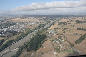
Hawke’s Bay’s hot, dry weather means rural residents are facing water take bans on many rivers and streams, while urban residents face restrictions across much of the region.
There are currently restrictions and bans on taking water on 16 sites across Hawke’s Bay. There is no significant rain forecast and further restrictions are likely.
The Tukituki and Waipawa Rivers are on full ban, while a ban is imminent on the Ngaruroro River at Fernhill. A water take ban means consent holders are prohibited from taking water from the rivers or streams affected.
People with resource consents to take water receive an email or text from the Hawke’s Bay Regional Council informing them of any restrictions or bans and up to date information on the situation is also available on the regional council website – www.hbrc.govt.nz #lowflows
Hawke’s Bay Regional Council Environmental Compliance Officer, Rob Hogan says the Compliance team is monitoring any exceedances and following up with any consent holders not complying with their resource consent conditions.
He says it is important consent holders keep their contact details up to date with the regional council so they can be informed of any restrictions or bans.
For urban residents, both Hastings District and Central Hawke’s Bay are on level three water restrictions which means sprinkler use is prohibited, however hand held hoses can be used on alternate days only, at limited times. Meanwhile Napier City is on Level 2 restrictions which means using sprinklers on alternate days, at limited times.
The Hawke’s Bay Regional Council’s Central Hawke’s Bay Councillor Will Foley says it is a difficult time for those affected by the water take bans, but managing the region’s water resource is a balancing act for the environment and the economy.
“As a Regional Council we feel for those on water bans and also those where their own water supply whether it be wells, creeks or springs have run dry. This current dry spell highlights the importance of our Regional Water Security Programme, which aims to make our region more resilient in these dry periods,” says Councillor Foley.
The programme includes the 3D aquifer mapping project, currently underway, which is one of four freshwater projects announced during the Provincial Growth Fund allocations to Hawke’s Bay in June last year. The others are a whole-of-region freshwater assessment, and pre-feasibility investigations on a Heretaunga flow maintenance/water storage initiative, and a Tukituki water security initiative.
Hawke’s Bay Regional Council’s Principal Climate Scientist, Dr Kathleen Kozyniak says there is very little rain in the forecast this week, but temperatures are expected to cool down later in the week.
To see details of the rivers and streams with restrictions and bans visit www.hbrc.govt.nz #lowflows
+64 6 835 9200
159 Dalton Street. Napier 4110
Private Bag 6006, Napier 4142
Disclaimers, Copyright & Privacy
![]()
Disclaimers and Copyright
While every endeavour has been taken by the Hawke's Bay Regional Council to ensure that the information on this website is
accurate and up to date, Hawke's Bay Regional Council shall not be liable for any loss suffered through the use, directly or indirectly, of information on this website. Information contained has been assembled in good faith.
Some of the information available in this site is from the New Zealand Public domain and supplied by relevant
government agencies. Hawke's Bay Regional Council cannot accept any liability for its accuracy or content.
Portions of the information and material on this site, including data, pages, documents, online
graphics and images are protected by copyright, unless specifically notified to the contrary. Externally sourced
information or material is copyright to the respective provider.
© Hawke's Bay Regional Council - www.hbrc.govt.nz / +64 6 835 9200 / info@hbrc.govt.nz