Current filter:
Published: 20 November 2020
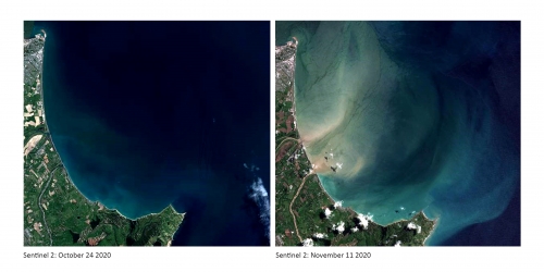
Hawke’s Bay Regional Council satellite imagery shows hundreds of thousands of tonnes of sediment in some of our major rivers, and 20 kilometres offshore following last week’s storm.
The first satellite image shows the bay between Napier Port and Cape Kidnappers in October this year, and the other image was taken after the storm struck, on Wednesday, November 11.
It shows sediment clogging up some of our major rivers, Tūtaekurī, Ngaruroro and Clive, and being discharged from these rivers and out to sea.
Council group manager of integrated catchment Iain Maxwell says that the science team are still analysing water samples to measure how much sediment was carried during the flood, but estimate that it was hundreds of thousands of tonnes.
“These satellite images reveal a telling picture of the ripple effect set in motion when we experience a major event of this kind. The storm has dislodged large volumes of potentially productive soil from our vulnerable, eroding hill sides, and this has entered our rivers, and gone as far as 20 kilometres offshore, ” he said.
Sediment impacts rivers and the coast by reducing water clarity, removing habitats for small aquatic animals, and the ability of fish to find prey. On the coast, it is problematic for algae that use sunlight for photosynthesis, and they struggle to survive, leading to a loss of habitat, he said.
Regional council modelling shows 252,000 hectares of Hawke’s Bay hill country is prone to erosion.
“As our climate changes, and storms and drought become more intense and frequent, it is important that we restore our vulnerable land, and increase the quality of our waterways,” he said.
“The most effective way to prevent erosion on vulnerable hill slopes is to plant trees, and that’s why we are exploring how we can upscale our tree planting programme, and plant the right trees in the right places.”
+64 6 835 9200
159 Dalton Street. Napier 4110
Private Bag 6006, Napier 4142
Disclaimers, Copyright & Privacy
![]()
Disclaimers and Copyright
While every endeavour has been taken by the Hawke's Bay Regional Council to ensure that the information on this website is
accurate and up to date, Hawke's Bay Regional Council shall not be liable for any loss suffered through the use, directly or indirectly, of information on this website. Information contained has been assembled in good faith.
Some of the information available in this site is from the New Zealand Public domain and supplied by relevant
government agencies. Hawke's Bay Regional Council cannot accept any liability for its accuracy or content.
Portions of the information and material on this site, including data, pages, documents, online
graphics and images are protected by copyright, unless specifically notified to the contrary. Externally sourced
information or material is copyright to the respective provider.
© Hawke's Bay Regional Council - www.hbrc.govt.nz / +64 6 835 9200 / info@hbrc.govt.nz