Current filter:
Published: 1 December 2020
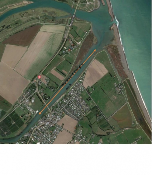
The Clive River is dredged around every ten years to allow recreational use, and is next planned for 2021 depending on resource consent.
The dredging takes around three months says Regional Council Regional Asset Manager Martina Groves.
“The dredging will cover 1,200 metres, from the river mouth to above the Clive Bridge. Around 50,000 cubic metres of sediment will be dredged and disposed of out to sea.”
“The Clive River is valued by the whole community and used by lots of people. Sediment builds up over time and needs to be removed. It’s important that the river is deep enough for recreational use and can continue to protect the community from flooding,” says Ms Groves.
“Through the consenting process we carry out, we will notify the public of the consent application in December. If the consent application is accepted, dredging will begin in February 2021.”
“We’ve been talking with tangata whenua and river users over the last few years about the dredging, and will continue engaging with them through this process.”
“Part of the dredging phase will involve environmental monitoring, looking at the effect the sediment is having when moved to the sea. Studies we’ve already done show that the environmental impact is minimal, but we want to make sure of this, so we will be checking as we go.”
“The dredging is made more difficult by a number of factors including cost, availability of the only dredge in New Zealand, the spawning season for wildlife in the river including whitebait, and recreational use.”
Dredging was first carried out in 1997 and again in 2009.
The dredging of the river is part of the Regional Council’s management of rivers to protect the community from flooding and to manage the wildlife and biodiversity habitat that the river supports.
ENDS
Editorial Note:
Until 1969 the lower Clive River was part of the Ngaruroro River. In 1969 the Ngaruroro River was diverted entirely down a new channel, providing relief from frequent flooding in Clive and Hastings. This resulted in a drastic change of flow pattern in the lower Clive River. A consequence of this is a build-up of silt over the river-bed which was previously gravel. Lower and slower river flows have meant that sediment is no longer transported to the coast.
+64 6 835 9200
159 Dalton Street. Napier 4110
Private Bag 6006, Napier 4142
Disclaimers, Copyright & Privacy
![]()
Disclaimers and Copyright
While every endeavour has been taken by the Hawke's Bay Regional Council to ensure that the information on this website is
accurate and up to date, Hawke's Bay Regional Council shall not be liable for any loss suffered through the use, directly or indirectly, of information on this website. Information contained has been assembled in good faith.
Some of the information available in this site is from the New Zealand Public domain and supplied by relevant
government agencies. Hawke's Bay Regional Council cannot accept any liability for its accuracy or content.
Portions of the information and material on this site, including data, pages, documents, online
graphics and images are protected by copyright, unless specifically notified to the contrary. Externally sourced
information or material is copyright to the respective provider.
© Hawke's Bay Regional Council - www.hbrc.govt.nz / +64 6 835 9200 / info@hbrc.govt.nz